
Sisson Callahan National Recreational Trail, Redding
Mount Shasta is located in northern California, east of Interstate 5 along SR89, between Mount Shasta city and McCloud city, California, USA.
Home > MOUNTAIN SPORTS > Backpacking / Trekking > Mt Alford Track, Methven
Methven has hot and dry summers, with temperatures that can reach up to 30°C/86°F, and cold winters with frequent snowfalls in the surrounding mountains. Although during summer it remains a relaxed and uncrowded town, during winter it is converted to a tourist attraction due to the nearby ski fields.
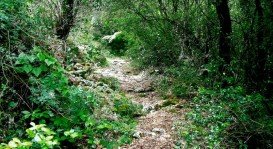
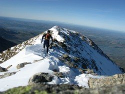
One of the best and most challenging ways to explore the wider area of Methven is trekking. Mt Alford Track passes through the Alford Scenic Reserve and climbs steadily to the peak of Mt Alford (1,171 m/3,841 ft).
Prepare yourself for a challenging and demanding track with rocks, steep and muddy sections. You will need to cross unbridged streams and creeks on several occasions before getting to the summit of the mountain. Enjoy the spectacular view of the Canterbury Plains and the surrounding mountains when you get to the top.
Note: For more details on the trails and tracks check with the Information Center.
Mount Shasta is located in northern California, east of Interstate 5 along SR89, between Mount Shasta city and McCloud city, California, USA.
Located almost at 150 km/93 mi from Nairobi City, Mt. Kenya is located just south of the equator, offering three climbing routes, namely Naro-Moru, Sirimon and Chogoria. Mt. Kenya has magnificent cliffs and glaciers that protect the highest peaks. Highest peaks here are Batian at 5199 m/17057 ft, Nelion at 5188 m/17021 ft and Point Lenana at 4985 m/16355 ft.
Sonora Pass is located near Pinecrest, Tuolumne County, California, USA. It is off of Highway about 60 mi/96.5 km east of Sonora.
Manaslu range, the ‘’spirit mountain’’, situated in the western Nepal on the border line between Nepal and Tibet, covers a 1663 km²/ 642 mi² area in the Mansiri Himal range of the Himalayas in the Gorkha District, Nepal. The conservation area starts at 600 m/1968 ft above sea level while Manaslu mountain at 8613 m/28257 ft altitude is listed in the eighth position among the highest mountain peaks worldwide.
Te Anau is a small town, situated in Fiordland region, in the South Island of New Zealand.
Cromwell is a small town, situated in Otago region, in the South Island, New Zealand. It lies on the shores of Lake Dunstan and is located only at 55 km/34 mi from Wanaka and 62 km/38 mi from Queenstown.
Wanaka is a small town in Central Otago in the South Island of New Zealand, situated on the south side of Lake Wanaka.
Queenstown is considered by many sportsmen as the capital of extreme sports and adventure activities. It is situated in Otago region, in the South Island, New Zealand.
Methven is a small town in Canterbury region of the South Island. It is only 1.5 h drive at the west of Christchurch, the second largest city of New Zealand and is situated close to Mount Hutt, in the heart of Southern Alps.
Christchurch is situated in Canterbury region in the South Island, and is the second largest city of New Zealand. It represents the getaway to Antarctica, while lying next to Pegasus Bay and the Pacific Ocean.
Cromwell is a small town, situated in Otago region, in the South Island, New Zealand. It lies on the shores of Lake Dunstan and is located only at 34 mi/55 km from Wanaka and 38 mi/62 km from Queenstown.
Queenstown is considered by many sportsmen as the capital of extreme sports and adventure activities. It is situated in Otago region, in the South Island, New Zealand.
Cromwell is a small town, situated in Otago region, in the South Island, New Zealand. It lies on the shores of Lake Dunstan and is located only at 34 mi/55 km from Wanaka and 38 mi/62 km from Queenstown.