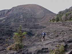
Mount Baldy, San Bernardino
Buckhorn Ski and Snowboard Club is located about 40 mi/64.3 km from Los Angeles, in the Angeles National Forest, near city Azusa, California, USA.
Home > MOUNTAIN SPORTS > Extreme Hiking / Hiking > Kīpukapuaulu Trail, Volcano National Park
The park is an international World Heritage site and provides visitors with several exciting hiking opportunities. Kipukapualu Trail or Bird Park is an easy route of 1.2 mi/2 km long, about one hour round trip and starts at Kipuka Puaulu parking lot on Mauna Loa road.
Hiking there is an amazing experience because you walk through the rainforest oasis, with an amazing variety of tropical birds specific in only Hawaii’s Big Island, insects and plantation, surrounded by lava flows form the Mauna Loa mountain. Hikers should wear hiking boots, take water and snacks, a raincoat, sunglasses, sunscreen and a hat because the sun can be very intense.
Due to the unstable terrain conditions, it is highly recommended, before choosing Kipukapualu Trail, to consult the Volcano National Park website for any park alerts that might prevent you from following this route.
Buckhorn Ski and Snowboard Club is located about 40 mi/64.3 km from Los Angeles, in the Angeles National Forest, near city Azusa, California, USA.
Wenatchee is the largest city of Chelan County, located in North Central Washington and lies on the west side of the Columbia River. The city is also known as the Apple Capital of the world, due to the valley's apple cultivations.
Mauna Loa is one of the five active volcanoes in the island of Hawaii, the largest one on earth in volume and in kilometers covered. Its peak stands at 13679 ft/4169 m above the sea level.
Sonora Pass is located near Pinecrest, Tuolumne County, California, USA. It is off of Highway about 60 mi/96.5 km east of Sonora.
In the North side of Kealakekua Bay, close to HI-11/ Hawaii Belt Rd, lies the monument of British explorer Captain Cook, who was killed in 1779. The road that leads to the monument is accessible by foot only.
Tombstones beach is located between Paukaa and Wainaku Village Hawaii, at about seven minutes drive from Hilo, which is the most populated city on the island.
Mauna Loa is one of the five active volcanoes in the island of Hawaii, the largest one on earth in volume and in kilometers covered. Its peak stands at 13679 ft/4169 m above the sea level.
Richardson's beach is located in Hilo, Hawaii, which is the most populated city of the island. Hilo is an old fashioned bay front town, with tropical rain forest climate all year long and home of the Tsunami Museum, dedicated to the understanding of the 1946 Pacific Tsunami.
Hillo's Brakewall is located in Hilo, Hawaii, which is the most populated city of the island. Hilo is an old fashioned bay front town, with tropical rain forest climate all year long and home of the Tsunami Museum, dedicated to the understanding of the 1946 Pacific Tsunami.
Mauna Kea is one of the five active volcanoes on the island of Hawaii, at 35 mi/56 km in the West of Hilo Town. Its peak is the highest point in the state, standing at 13803 ft/4207 m above the sea level.
The 4Miles beach is located in Hilo, in Hawaii, which is the most populated city of the island. Hilo is an old fashioned bay front town, with tropical rain forest climate all year long and home of the Tsunami Museum, dedicated to the understanding of the 1946 Pacific Tsunami.
Mauna Kea is one of the five active volcanoes on the island of Hawaii, at 35 mi / 56 km in the west of Hilo Town while its peak is the highest point in the state, standing at 13803 ft / 4207 m above the sea level.
Pololu Valley is the Northernmost valley, forming the East coast of the Kohala Mountain after Waipio Valley. The valley goes at 420 ft/128 m downwards and it ends at a beautiful beach with black sand.