
Mida Creek, Watamu Beach & Malindi
Watamu Beach is located at 120 km/74 mi in the north of Mombasa and 28 km/17 mi in the south of Malindi, the nearest big town.
Home > WATER SPORTS > Kayaking > Sturgeon River, Cheboygan County
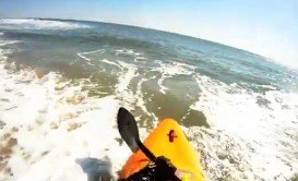
With an average drop of 14 ft (4.26 m), every mile of the Sturgeon River delivers unbeatable kayaking experience. A beautiful canopied river that starts out narrow, but with a strong current and good water level, averaging 3-4 ft/0.91–1.22 m and 6-8 ft/1.83–2.44 m at its deepest point, is full of tricky turns, leaning trees, logs and stumps and will definitely test your abilities. Though Sturgeon is not a whitewater river, you will find its clear water refreshing, as it is common to experience an unplanned dank!
As you maneuver through the Sturgeon River, the wildlife you see along the way or even one of the lovely river cottages of the northern Michigan forests will tempt you to stop paddling, sit back and let the current take you along. You have to keep in mind that you will find many natural obstacles that will challenge you and will require that you stay alert. Remember the water is too cold for unnecessary tip-overs.
Watamu Beach is located at 120 km/74 mi in the north of Mombasa and 28 km/17 mi in the south of Malindi, the nearest big town.
Sandbridge is a coastal community of Virginia Beach, situated along the coastline on the Currituck Banks Peninsula at the northern end of the Outer Banks.
Durban is a beautiful city and the biggest one in the KwaZulu - Natal. lt has an amazing coastline, diverse landscape with the most spectacular mountain range in South Africa. Climate is sub-tropical with warm wet summers, mild frost-free winters and all year round sunshine. Its amazing sandy beaches stretch into the Indian Ocean with water temperatures at 19°C/66.2°F even during winter.
The Marquesas Keys are a 6 km (4 mi) in diameter, uninhabited, pristine island group of the Lower Keys Census County Division. About 50 km (30 mi) west of Key West, where the Atlantic Ocean meets the Gulf of Mexico, the Marquesas islets are the best place to explore the unspoiled wilderness.
L'Argentière-la-Bessée is a commune of the Hautes-Alpes department in the Alps in southeastern France. The spot is situated next to the Durance river, which is used for kayaking and other water sports. The town is located on the edge of the Ecris National Park.
Torres del Paine is located in Southern Patagonia and is one of the numerous and spectacular national parks in Chile. It was created in 1959 and UNESCO has listed the location as a Biosphere Reserve since 1978. This place is a wonderland for nature enthusiasts from all over the world.
Lake Michigan is one of the five Great Lakes and the only one placed entirely within the United States. It has the same surface elevation as Lake Huron and it is the second largest of Great Lakes. The Straits of Mackinac join Lake Michigan with Lake Huron, sometimes called the Michigan-Huron. The Straits of Mackinac Underwater Preserve holds numerous shipwrecks, one of them being the Maitland.
Lake Michigan is one of the five Great Lakes, the only one placed entirely within the United States and the second largest Great Lake by volume. It has the same surface elevation as Lake Huron, making the two technically a single lake. The Straits of Mackinac connects Lake Michigan and Lake Huron. Over the years, many ships have sunk in the Straits. One of the shipwrecks lying in the Straits of Mackinac Underwater Preserves is St. Andrew.
Lake Huron is the second-largest of the Great Lakes and the third largest fresh water lake on Earth, with more than a thousand wrecks being recorded. At least eleven of these shipwrecks are contained in the Straits of Mackinac Shipwreck Preserve. 3 mi/4.8 km east of Mackinac Bridge lies what's left of the Cedarville. Being in a very good condition, because of its close proximity to the surface, the shipwreck has much to explore.
Lake Huron is the second-largest of the Great Lakes and the world's third-largest freshwater lake. It has also the largest shore line length of any of the Great Lakes. Lake Huron and Lake Michigan lie at the same level, but are separated by the narrow Straits of Mackinac. One of the shipwrecks, sheltered in the Straits of Mackinac is the Northwest.
Grand Traverse Bay is a 32 mi/ 51km long and a 10 mi/ 16 km wide bay, divided in two parts by the old Mission Peninsula. The Grand Traverse Bay Underwater Preserve, founded in 2005, holds the wrecks of many ships lost in the area the previous years.
Lake Michigan’s basin is conjoining with that of Lake Huron to the east and having the same surface elevation, they are technically a single lake. The large size of the Lakes and the fact that they are prone to sudden and harsh storms, combined with the rocky shoals and shallows of Straits of Mackinac, increases the risk of water travel and has led hundreds of ships to their end.
Lake Michigan’s basin is conjoining with that of Lake Huron’s to the east and having the same surface elevation, Lake Michigan and Lake Huron are technically a single lake. The Straits of Mackinac Underwater Preserve lies at the northern tip of Lakes Michigan and Huron and tries to preserve Michigan’s shipwrecks for later generations. One of the shipwrecks that has been found is that of Sandusky.
Located in Michigan's Upper Peninsula, St. Ignace is the connecting node between the Upper and Lower Peninsula at the northern end of the Mackinac Bridge. Saint Ignace is the second-oldest city founded by Europeans in Michigan and the third oldest continuously inhabited city in the U.S. It is inhabited by Native Americans, Europeans and is rich in history. With its pristine beaches, water filled activities, entertainment, history and annual events, St. Ignace is a great vacation destination for all.