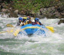
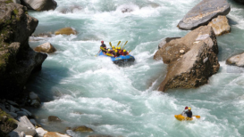
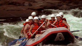
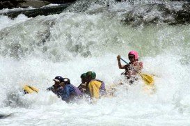
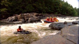
Rafting in Padas River, Kota Kinabalu,
Sabah Malaysia
Distance :
23km/14.3mi
Rapid Grade :
Class III-IV
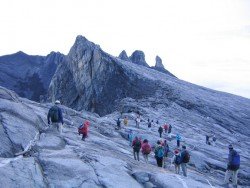
Famous due to its proximity with tropical islands, lush forests and Mount Kinabalu, Kota Kinabalu is the capital of the state of Sabah located in Borneo. It is located on the west coast of Sabah within the West coast Division. Formerly known as Jesselton, it enjoys a tropical rainforest climate and lies by the coast, overlooking at the South China Sea and bordered by the Crocker range which is home to Mount Kinabalu.
Padas River is located at the most interior part of south-western part of Kota Kinabalu and can only be accessed by train. The Padas river flows through the amazing Padas Gorge and white water rafting the Padas promises a thrilling and adrenaline rush for both the novice and expert paddler. The rapids’ sweet names like “scoobydoo” “merry-go-round” might fool you but they sure will give you the chills and test your paddling skills to the maximum!!
The paddling covers a distance of 23 km/14.3 mi long with 7 exhilarating rapids graded between class III-IV. The rapids starting point is at a traditional village, called Pangi which is home to the local Murat tribe who were previously head hunters!! Safety is at top notch as there are guides who take you through this thrilling adventure. Minimum age requirement here is 12 years old with some level of fitness and advance booking is necessary.
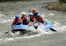
The Bhote Koshi river stems from Tibet and is part of the Koshi River System. It is considered to be as the steepest and most ranging river in Nepal. Here, rafting can be only extreme and absolutely exciting!
Jacques Cartier River is a river in the province of Quebec, located at 161 km/100 mi (30 minutes) away from Quebec City. The river's springs are spotted close to Jacques Cartier Lake in Laurentides and the river flows in a southern direction in the Sainte Lawence River at Donnocona.
The Free State is situated on the flat boundless plains in the heart of South Africa. Known locally as the "breadbasket" of South Africa, it is an agricultural city and most of its land lies at 1000 m/3281 ft above sea level. It is the land of rugby, sunny skies and characterized by a continental climate, with warm to hot summers and cool to cold winters.
Rouge River is a river in western Quebec, Canada that flows through Mont Tremblant, dumping into Ottawa River. It is located in Laurentides between Ottawa and Montreal. Rouge River has a lot of points in its favor, thanks to its wilderness and exceptional natural beauty.
Famous due to its proximity with tropical islands, lush forests and Mount Kinabalu, Kota Kinabalu is the capital of the state of Sabah located in Borneo. It is located on the west coast of Sabah within the West coast Division. Formerly known as Jesselton, it enjoys a tropical rainforest climate and lies by the coast, overlooking at the South China Sea and bordered by the Crocker range which is home to Mount Kinabalu.
Famous for its proximity with the tropical islands, lush forests and Mount Kinabalu, Kota Kinabalu is the capital of the state of Sabah located in Borneo. It is located on the west coast of Sabah within the West coast Division. Formerly known as Jesselton, it enjoys a tropical rainforest climate and lies by the coast overlooking the South China Sea and bordered by the Crocker range which is home to Mount Kinabalu.
Famous due to its proximity with tropical islands, lush forests and Mount Kinabalu, Kota Kinabalu is the capital of the state of Sabah located in Borneo. It is located on the west coast of Sabah within the West coast Division. Formerly known as Jesselton, it enjoys a tropical rainforest climate and lies by the coast, overlooking at the South China Sea and bordered by the Crocker range which is home to Mount Kinabalu.
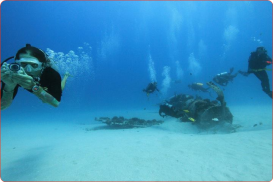
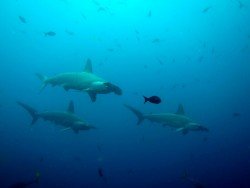
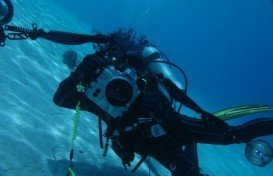
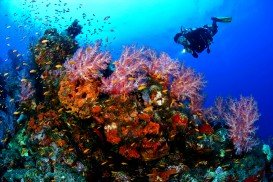
Pulau Tiga is located at 48 km/30 mi in the south of Kota Kinabalu and became well known due to the "Survivor" series, hosting the setting of "Survivor Borneo", the first American season of the show. Scuba diving in Pulau Tiga is open to all levels of divers and is a prime location for macro lovers and underwater photography. The spot is believed to have been formed by the eruption of several mud volcanoes and is at 100 m/328 ft above sea level.
Famous for its proximity with tropical islands, lush forests and Mount Kinabalu, Kota Kinabalu is the capital of the state of Sabah located in Borneo. It is located on the west coast of Sabah within the West coast Division. Formerly known as Jesselton, it enjoys a tropical rainforest climate and lies by the coast, overlooking at the South China Sea and bordered by the Crocker range which is home to Mount Kinabalu.
Famous due to its proximity with tropical islands, lush forests and Mount Kinabalu, Kota Kinabalu is the capital of the state of Sabah located in Borneo. It is located on the west coast of Sabah within the West coast Division. Formerly known as Jesselton, it enjoys a tropical rainforest climate and lies by the coast, overlooking the South China Sea and bordered by the Crocker range which is home to Mount Kinabalu.
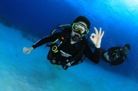
Pulau Tiga is located at 48 km/30 mi in the south of Kota Kinabalu and became well known due to the "Survivor" series, hosting the setting of "Survivor Borneo", the first American season of the show. Scuba diving in Pulau Tiga is open to all levels of divers and is a prime location for macro lovers and underwater photography. The spot is believed to have been formed by the eruption of several mud volcanoes and is at 100 m/328 ft above sea level.
Famous due to its proximity with tropical islands, lush forests and Mount Kinabalu, Kota Kinabalu is the capital of the state of Sabah located in Borneo. It is located on the west coast of Sabah within the West coast Division. Formerly known as Jesselton, it enjoys a tropical rainforest climate and lies by the coast, overlooking the South China Sea and bordered by the Crocker range which is home to Mount Kinabalu.
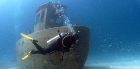
Pulau Tiga is located at 48 km/29.9 mi in the south of Kota Kinabalu and became well known due to the "Survivor" series, hosting the setting of "Survivor Borneo", the first American season of the show. Scuba diving in Pulau Tiga is open to all levels of divers and is a prime location for macro lovers and underwater photography. The spot is believed to have been formed by the eruption of several mud volcanoes and is at 100 m/328 ft above sea level.