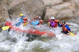
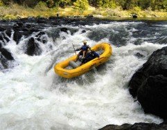
Rafting in Storms River, Tsitsikamma,
Western Cape South Africa
Rapids:
Up to Grade 3
Best Months:
September - November
Water Levels:
Medium to High
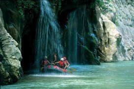
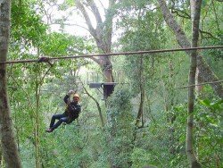
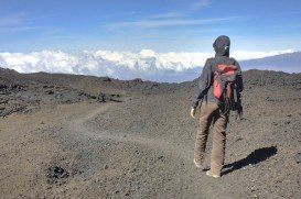
The Tsitsikamma area is a large wrapped with Afromontane forest and fynbos with deep river gorges, flowing through to the sea and forming spectacular waterfalls and deep kloofs. It is situated on the eastern edge of the Garden Route Between Nature's Valley and Eerste Riviera within the Tsitsikamma National Park.
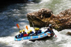
Rafting is conducted at the amazing Storm River with its waters classified as swift and water levels of medium to high.
Rafting is not only for the adrenalin filled but the spot’s steep, fern-filled walls and thickly forested banks over magnificent bird life and wildlife. Rafting trips last for about 5 hours filled with utter excitement. Depending on water levels, you can raft when the water is at low levels or when the river is flowing strongly with rapids up to grade 3 and rock faces as high as 8 m/26 ft in to the deep waters. September to November offer the most rapids with water levels at medium to high.
Advance booking is necessary and the trip normally begins at 7 am.
Saint Martin du Puy is a small rural community, gathering eight villages in Burgundy of central France. The village of ''Plainfas'' is the most populated one and it is located near a beautiful lake, called Lac du Caumecon.
Epirus is a geographic and administrative region, located in northwestern Greece. It is considered to be the region with the more rainfall than any other part of the country. In fact, Epirus offers imposing landscapes of outstanding natural beauty as well as a wide variety of fauna and flora.
Paiva River is a well-known Portuguese river, located in Serra Leomil and more particularly in the perish of Old Pear. The river flows into the Douro in the Castelo de Paiva.
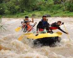
Java is the 5th largest island in Indonesia and the world's most populous as well. It acts as Indonesia's center of cultural and economic activity. Java is divided into four provinces, West Java, East Java, Central Java and Banted plus two additional special regions, Jakarta and Yogyakarta. Java is almost entirely of volcanic origin and lies between Sumatra to the west and Bali to the east.
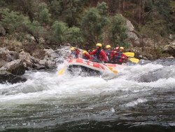
Berthoud Pass is located between Idaho Springs and Winter Park and is one of the closest areas in Denver for whitewater rafting. It belongs to Boulder County and is just an hour away.
Mossel Bay is a beautiful coast, located between Cape Town and Port Elizabeth, at 400 km/248 mi of distance both ways. It is surrounded by the sunbathed peninsula and the beautiful waters of the Indian Ocean. The spot offers a mild climate all year round making it a perfect winter break destination.The weather is influenced by the Aghulas current of the Indian Ocean and by the presence of the Outeniqua mountains.
Mossel Bay is a beautiful coast, located in between Cape Town and Port Elizabeth, at 400 km/248 mi of distance both ways. It is surrounded by the sunbathed peninsula and the beautiful waters of the Indian Ocean. It offers a mild climate all year round, making it a perfect winter break destination.The weather is influenced by the Aghulas current of the Indian Ocean and by the presence of the Outeniqua mountains.
Mossel Bay is a beautiful coast, located in between Cape Town and Port Elizabeth, at 400 km/248 mi of distance both ways. It is surrounded by the sunbathed peninsula and the beautiful waters of the Indian Ocean. It offers a mild climate all year round, making it a perfect winter break destination.The weather is influenced by the Aghulas current of the Indian Ocean and by the presence of the Outeniqua mountains.
Mossel Bay is a beautiful coast, located between Cape Town and Port Elizabeth, at 400 km/248 mi of distance both ways. It is surrounded by the sunbathed peninsula and the beautiful waters of the Indian Ocean. It offers a mild climate all year round, thus making it a perfect winter break destination.The weather is influenced by the Aghulas current of the Indian Ocean and by the presence of the Outeniqua mountains.
Garden Route is a popular stretch of the south-eastern coastline of South Africa. It is sand-witched between the Indian Ocean and the Outeniqua and Tsitsikamma Mountains. It has a mild oceanic climate with mild to warm summers and mild to cool winters and considered second mildest climate after Hawaii according to the Guinness Book of Records.
Garden Route is a popular stretch of the south-eastern coastline of South Africa. It is sandwitched between the Indian Ocean and the Outeniqua and Tsitsikamma Mountains. It has a mild oceanic climate with mild to warm summers and mild to cool winters and considered second mildest climate after Hawaii according to the Guiness Book of Records.
Wilderness is a resort, lying between the Outeniqua mountains and beautiful warm waters of the Indian Ocean in Western Cape, South Africa. A rich natural landscape with beautiful beaches and a number of rivers and lakes, Wilderness offers considerable amount of tranquility making it a perfect beach holiday spot. Climate is warm all year round with winters offering sunny and warm days.
Garden Route is a popular stretch of the south-eastern coastline of South Africa. It is sandwiched between the Indian Ocean and the Outeniqua and Tsitsikamma Mountains. It provides with a mild oceanic climate with mild to warm summers and mild to cool winters and considered second mildest climate after Hawaii according to the Guinness Book of Records.