Zanoni Shipwreck, Ardrossan
The Zanoni Shipwreck, located at 10 nautical miles off the coast of Ardrossan, is one of the well preserved shipwrecks in Australia and one of the most complete 19th century's shipwrecks in South Australia.
Home > WATER SPORTS > Scuba Diving > General Rogers, Saint Thomas
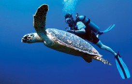
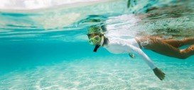
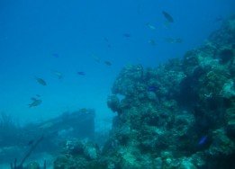
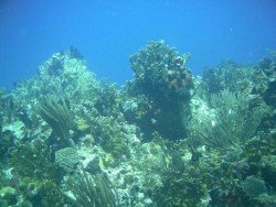
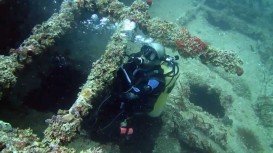
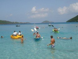
St. Thomas is home to a collection of outstanding wreck dive sites. With an amazing array of coral reefs, a variety of fish species and crystal clear waters, this tropical destination attracts divers and snorkelers from all over the world. The majority of the locations are accessible by boat, but there are also some excellent dive spots just right from shore.
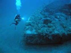
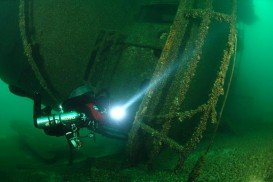
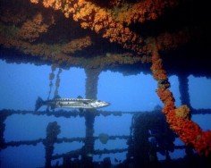
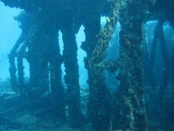
The General Rodgers was a Coast Guard vessel that lies almost intact in a channel off the northwest side of St. Thomas. Divers of all experience levels can swim through passageways and explore the decks and the open cargo holds. The ship sits upright in 21.3 m/69.9 ft of water and hosts an abundant marine life. The hulk is surrounded by colorful soft and hard corals and tube sponges. Schools of barracuda, jacks, grunts and snapper can be seen here.
The average water temperature varies from 75°F/24°C in winter to 80°F/27°C in summer and the visibility ranges from 10 m/32.8 ft to 30 m/98.4 ft. Keep in mind that the spot is usually affected by a strong current. In the end, you should book your dive in advance, as access to the dive site is only by boat. So, if you feel like exploring the underwater world, General Rodgers guarantees a one in a lifetime experience!!!
The Zanoni Shipwreck, located at 10 nautical miles off the coast of Ardrossan, is one of the well preserved shipwrecks in Australia and one of the most complete 19th century's shipwrecks in South Australia.
Trinidad and Tobago is an island country that is situated just off the coast of northeastern Venezuela. Both Trinidad and Tobago islands surprise visitors with their unspoiled natural beauty that is not found in most of the other Caribbean islands. The climate here is classified as tropical with two seasons annually, the dry and rainy season and the winds are usually influenced by the northeast trade winds. The islands are known not only for their beautiful sandy beaches, but also for their carnivals.
Watamu Beach is located at 120 km/74 mi in the north of Mombasa and 28 km/17 mi in the south of Malindi, the nearest big town. The shoreline of this area consists of white sandy beach and offshore corals, forming three bays, namely Watamu bay, Turtle bay and Blue Lagoon. The bay is protected by a coral reef at almost 0.5 km off the shore.
Perth is the capital city of Western Australia, located on the Swan River. The climate here is classified as Mediterranean, with hot and dry summers and cool and wet winters. Immerse yourself in the unique combination of stunning natural surroundings, beautiful beaches with clear waters, greenery park-lands and outstanding city architecture that attract visitors all year long.
Lake Huron is the second-largest of the Great Lakes and the third largest fresh water lake on Earth, with more than a thousand wrecks being recorded. At least eleven of these shipwrecks are contained in the Straits of Mackinac Shipwreck Preserve. 3 mi/4.8 km east of Mackinac Bridge lies what's left of the Cedarville. Being in a very good condition, because of its close proximity to the surface, the shipwreck has much to explore.
Prickly Pear Cays are a pair of uninhabited islands, the Prickly Pear East and the Prickly Pear West. They are about at 9.6 km/6 mi in the north-western of Anguilla. Anguiila belongs to the Leeward Islands in Caribbean Sea. It is located on the north of Saint Martin and on the west of Puerto Rico and the Virgin Islands.
The Virgin Islands of the United States, or the U.S. Virgin Islands lie in the Caribbean Sea, east of Puerto Rico. This group of islands consist of the main islands of Saint Thomas, which is home to the capital city of the U.S. Virgin Islands, Saint John, Saint Croix, Water Island and other surrounding minor islands.The climate here is classified as tropical savanna climate, mostly affected by moderate trade winds.
